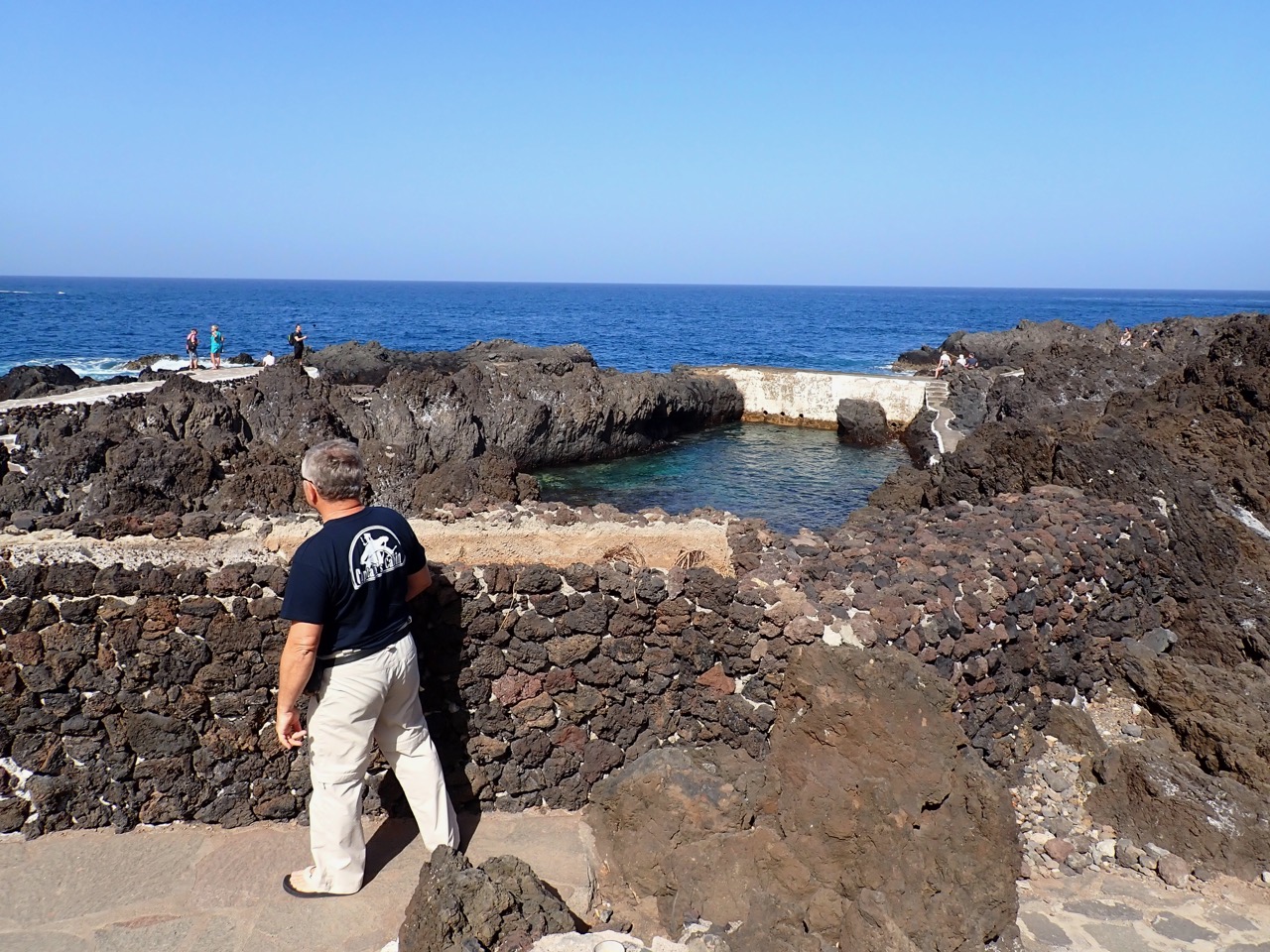
On Friday morning we studied the map of Tenerife and came up with a plan for a road trip on roads where we haven't driven yet. We decided to drive along the North coast of the island as far West as we can, then down along the West coast and then along the South coats back towards our marina. Our first stop was the small town of Garachico. We read about how pretty and unlucky the town is. It was the most important and wealthiest port in Tenerife until 1706, when Montana Negra erupted and the lava erased most of the town. Lava also filled most of the natural port in front of the town, but at the same time created unusual natural swimming pools. The pools were really interesting, I guess they are open for swimming only in summer and we couldn't walk around it.
But it looked nice and I'm sure there's lots of people here on these rocks when the weather is hot and the sea a bit warmer.
This is one of the buildings that escaped lava.
And these are remains of the old town doors, now located in the park.
There is still plenty of pretty buildings, built after the eruption. But after it the town never regained the status that it had before. Which in my eyes might not be such a loss, because it retained it's charm and it is one of very few towns in Tenerife that is not surrounded by concrete jungle of tourist developments.
A smaller bay of what once was a big and important port is still there. On the slope you can see where the lava came down to the tow and the port.
It's not just pretty, but we also had the best ice cream in Spain here.
From Garachico we drove West to the town of Buenavista del Norte. We tried to get to the most NW point of the island, but the road was closed for everyone except busses and organised tours from 10 in the morning til 7 in the evening. Apparently there are not enough parking spaces at the end of the road for everyone that want to drive there. So we turned South and drove into the hills. I'm not sure if this hill is falling apart because of the erosion or is this man made.
We stopped on one of the miradors. While it wasn't very high, only about 1000m, it was cold and misty. The visibility was also not the best, but I guess the mist helps all those plants to grow.
These looked like some sort of giant mountain dandelions.
Next we drove to the village of Masca. Above the village there are some nice mountains.
The plant in the front of the photo looked like some sort of anise or dill plant.
We parked our car above the village and walked down. The village is built on the ridge above the gorge. This is a small square with big tree in the upper part of village.
This is the view of the rest of the village. It is very pretty and luckily we were there rather late in the afternoon when most of the tourists were already gone. It is very popular tourist attraction, mentioned in every guide or top 10 list.
We strolled down into the village through narrow steep streets. I discovered some pretty flowers.
After a walk around we ended in a restaurant and this was the view from our table.
And this...
And on top of everything, the food was delicious. It really is a pretty place, surprisingly cam and tranquil. The almond trees were in bloom and full of bees.
I was surprised that we also found a mango tree...
...and an avocado tree.
Maybe this is where the avocados for our meal came from, it said on the menu "avocados from our garden".
We continued our drive towards South through the hills. You can see the road on the slope of the hill in the cloud.
I'm not sure what this is, but it was very pretty.
Some more rocks from along the road...
Our next stop was the resort town of Los Gigantes, named by the cliffs of the same name to the North of the town. There is also a marina there. We only stopped in mirador little above the town for couple of minutes, since it was getting late and we still had a long way home. Maybe we'll have a closer look at some other time.


No comments:
Post a Comment